Outdoor burning temporarily outlawed by some

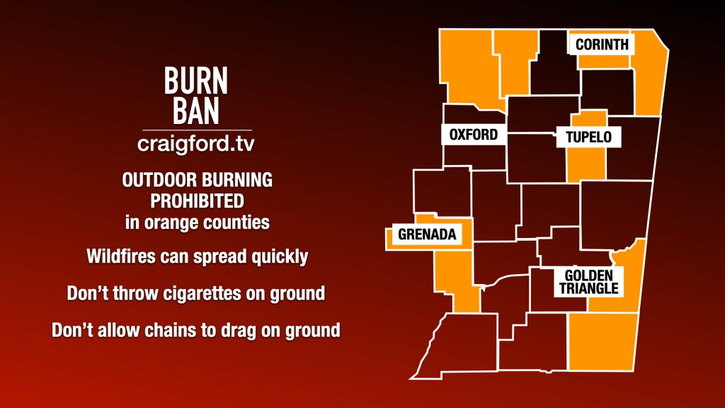
Click here to see the exceptions for each county’s burn ban and when they expire.

What’s not allowed

Anything with an open flame that produces an ember, such as:

  • Campfires
  • Bonfires
  • Fire pits
  • Fire rings
  • Burn barrels
  • Debris burning
  • Field burning

The wind can carry floating embers away from the original fire and start a spot fire up to one-half mile away from the burning area.

What’s allowed

  • Propane/Gas grills
  • Propane/Gas heaters
  • Charcoal grills

Charcoal grill briquettes are of great concern. After use, always let the coals cool completely and douse in water before disposing of them in a metal container. The residual ash should be cold to the touch before disposal.

What came from Sunday’s severe weather

Here is the information provided Monday night from the National Weather Service in Memphis:

..Kossuth, MS Tornado…

Rating: EF1
Estimated Peak Wind: 100 mph
Path Length /statute/: 2.58 miles
Path Width /maximum/: 100 yards
Fatalities: 0
Injuries: 0

Start Date: 03/15/2026
Start Time: 08:17 PM CDT
Start Location: 1 NNE Kossuth / Alcorn County / MS
Start Lat/Lon: 34.8912 / -88.6302

End Date: 03/15/2026
End Time: 08:20 PM CDT
End Location: 4 NE Kossuth / Alcorn County / MS
End Lat/Lon: 34.9085 / -88.5911

Survey Summary:
An EF1 tornado started just to the west of the intersection of
County Road 636, causing minor roof damage to a home. The tornado
continued east across County Road 602, County Road 616, County
Road 627, and County Road 628, snapping uprooting numerous trees,
downing powerlines, damaging fences, and causing minor roof
damage. Continuing east along Highway 2, the tornado caused minor
damage to roofs of several homes. The tornado then intensified
causing the most extensive damage at a church, removing part of a
roof and blowing out a few windows. The tornado then made its
final trek northeast along County Road 502, causing minor roof
damage to a home before lifting over open fields.

How TV weather has changed

WBAP-TV weather intro

Found this report below on Harold Taft, the meteorologist credited with launching the country’s first regular television weather segment on Halloween of 1949 on what was then WBAP-TV (now KXAS-TV) in Dallas-Fort Worth. He also did the weather on the overnight trucking show on WBAP-AM, which was heard across the country. Taft’s final television weathercast was in August 1991. He died from cancer a month later at age 69.

Bitter cold coming

A mild Saturday will give way to bitter cold Sunday into Monday with it feeling like it’s in the teens or single digits across Northeast Mississippi. They won’t be as low in the Golden Triangle as it will be in Corinth, but it’ll still be cold.

The low temperatures/wind chills will first arrive Sunday morning. There will be a slight rise during the day, but the low temperatures/wind chills arrive again after sunset Sunday and stick around into early Monday. As the north winds subside, we’ll actually be a little warmer Monday.

Looking ahead, the government’s long range forecast for the week of Christmas has temperatures above normal.

We may get wet next week

The Climate Prediction Center on Monday said there is a 40 to 60 percent risk of heavy rainfall for Mississippi during the middle of next week.

That risk also includes west Alabama, west Tennessee, most of Arkansas, southeast Oklahoma, east Texas and all of Louisiana.

As you can see below, there is an area beyond that with a slight risk of heavy rainfall from Tuesday through Saturday of next week.

About that severe weather threat

Looks like that severe weather threat for Northeast Mississippi has diminished significantly from what was originally expected. The National Weather Service has trimmed the area for a marginal risk to roughly east of Corinth-Tupelo-Columbus.

And the marginal threat for severe storms on Saturday is gone.

However, the below-freezing weather is coming by the end of the weekend.